|
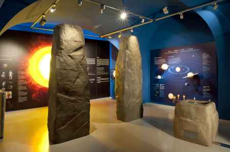
aktuálně -5.7 °C zataženo 04.02. | zataženo | 1.8 °C 05.02. | zataženo | 1.9 °C 06.02. | slabý déšť | 3.5 °C | Exhibition of timePlay a space game, get your picture taken by the Hubble telescope and learn about the process of the origin of the universe and time!The 14-billion-year story since the Big Bang is chronicled by unique exhibits from more than 20 Czech and international museums, 3D models and interactive games. The Time Exposition shows that philosophers, astronomers, cosmologists, mathematicians, physicists, artists and craftsmen from all over the world have been involved in the search for the mysteries that surround time. You will also see a collection of rare clocks, understand the differences between calendars and time in different cultures and times, and learn the principles of timekeeping. In Sternberg, we also recommend visiting the nearby castle and monastery with its many exhibitions and displays. 0%
| ||||||||||||||||||||||||||||||||||||||||||||||||
The system of interactive links for individual records in selected modules within the project Central Moravia - mainly quiet (2024) was implemented with the support of the state budget of the Czech Republic from the programme of the Ministry for Regional Development.
The optimization of the website and the online campaign within the project Adrenalin after ours (2023) were realized with the contribution of the state budget of the Czech Republic from the programme of the Ministry for Regional Development.
The website was created within the framework of the project Marketing TO Central Moravia 2020 implemented with the contribution of the state budget of the Czech Republic from the programme of the Ministry for Regional Development.
The operation and activities of Střední Morava – Sdružení cestovního ruchu (Central Moravia – Tourism Association) were supported by funds from the Czech Republic's state budget under a program of the Ministry of Regional Development of the Czech Republic.
