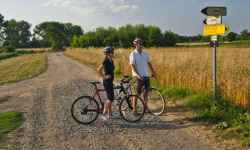
 | Mountain routeThe circular route starts at the information center in Šternberk with the sign 6009. From the center, you will climb up Opavská Street towards the start of the Ecce Homo line and further up to the vil ... (more) Obtížnost: těžká Čas: 420 minut Zážitek: Stoupání: 1305 metrů Klesání: 1309 metrů Krajina: Nejvyšší bod: 648 m.n.m. Nejnižší bod: 247 m.n.m. |
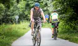
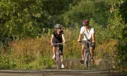
Cycling Šternberk
5 records
 | Cycle path Behind the Living WaterThe trail starts at the information center in Šternberk , following sign No. 6009. From the IC you will climb up Opavská Street towards the start of the famous Ecce Homo track and continue climbing un ... (more) Obtížnost: těžká Čas: 420 minut Zážitek: Stoupání: 1034 metrů Klesání: 1035 metrů Krajina: Nejvyšší bod: 695 m.n.m. Nejnižší bod: 275 m.n.m. |
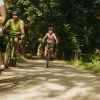
 | Cycle path to the zoo and for swimmingThe circular route starts and ends in Šterberk at the Upper Square in front of the information centre. Cyclists who take the trail have the opportunity to visit the zoo at St. Kopecek near Olomouc an ... (more) Obtížnost: středně těžká Čas: 269 minut Délka: 20.19 km Zážitek: Stoupání: 744 metrů Klesání: 748 metrů Krajina: Nejvyšší bod: 558 m.n.m. Nejnižší bod: 226 m.n.m. |
 | 30 kilometres through the surroundings of ŠternberkThe circular route starts and ends in Šternberk at the Upper Square in front of the local Information Centre. The highest point of the route is Chabičov, a local part of Šternberk, and then you wil ... (more) Obtížnost: lehká Čas: 180 minut Zážitek: Stoupání: 330 metrů Klesání: 349 metrů Krajina: Nejvyšší bod: 479 m.n.m. Nejnižší bod: 221 m.n.m. |
 | Tour de Wanzl cycle pathThe moderately demanding route is a circuit with the beginning and end at the village square of Jívová. The name of the route was chosen in honor of the local native and inventor of the shopping tro ... (more) Obtížnost: středně těžká Čas: 300 minut Délka: 49.94 km Zážitek: Stoupání: 988 metrů Klesání: 986 metrů Krajina: Nejvyšší bod: 644 m.n.m. Nejnižší bod: 355 m.n.m. |
5 records
 | New summer cyclobus from Olomouc to Konice! 24.06.2025 | |
 | Cycle bus Bečva to Beskydy! 29.05.2024 | |
 | How to transport a bike from Olomouc to Jeseniky? 28.06.2023 | |


The system of interactive links for individual records in selected modules within the project Central Moravia - mainly quiet (2024) was implemented with the support of the state budget of the Czech Republic from the programme of the Ministry for Regional Development.
The optimization of the website and the online campaign within the project Adrenalin after ours (2023) were realized with the contribution of the state budget of the Czech Republic from the programme of the Ministry for Regional Development.
The website was created within the framework of the project Marketing TO Central Moravia 2020 implemented with the contribution of the state budget of the Czech Republic from the programme of the Ministry for Regional Development.
The operation and activities of Střední Morava – Sdružení cestovního ruchu (Central Moravia – Tourism Association) were supported by funds from the Czech Republic's state budget under a program of the Ministry of Regional Development of the Czech Republic.