|
aktuálně 0.0 °C Adresa: Naplánovat trasuNávrší Jana Pavla II. 1/1 779 00 Olomouc - Svatý Kopeček Olomouc, Olomoucký Česko | Contact: 778 781 981
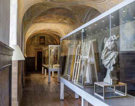
The Holly Hill museumIn the grounds of the pilgrimage basilica you can see valuable historical artefacts, including fragments of the oldest phase of the basilica's decoration, historical liturgical objects or a set of Baroque boxes with the relics of saints.The exhibition highlights the important pilgrimage character of the site, and in the hall of the former library you can also learn about contemporary aspects of pilgrimage. The history of the pilgrimage site at Sv. Kopeček began in the early 17th century, when the Olomouc merchant Jan Andrýsek had a chapel built on the hill near Olomouc. The place was similar to the one where the Virgin Mary appeared to him in a dream. Soon after, the construction of the monumental Baroque Church of the Visitation of the Virgin Mary began on the site of the chapel. 0%
| ||||||||||||||||||||||||||||||||||||||||||||||||
The system of interactive links for individual records in selected modules within the project Central Moravia - mainly quiet (2024) was implemented with the support of the state budget of the Czech Republic from the programme of the Ministry for Regional Development.
The optimization of the website and the online campaign within the project Adrenalin after ours (2023) were realized with the contribution of the state budget of the Czech Republic from the programme of the Ministry for Regional Development.
The website was created within the framework of the project Marketing TO Central Moravia 2020 implemented with the contribution of the state budget of the Czech Republic from the programme of the Ministry for Regional Development.
The operation and activities of Střední Morava – Sdružení cestovního ruchu (Central Moravia – Tourism Association) were supported by funds from the Czech Republic's state budget under a program of the Ministry of Regional Development of the Czech Republic.
