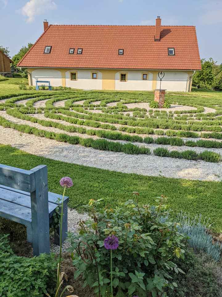
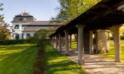
Lavender Labyrinth Lela
aktuálně 7.0 °C jasno
28.04. | oblačno | 17.6 °C
29.04. | zataženo | 19.4 °C
30.04. | oblačno | 19.7 °C
Kyžlířov 20, 753 62 Potštát, Přerov
Naplánovat trasu

Contact:

Kyžlířov 20
753 62 Potštát
Plan route

Lavender Labyrinth Lela

The lavender labyrinth is a smaller copy of the labyrinth in Chartres Cathedral in France and consists of 878 lavender seedlings.

A place for relaxation and tranquillity, surrounded by the omnipresent lavender scent. You can spend a pleasant afternoon in the labyrinth and take a piece of it home with you - the labyrinth hosts lavender picking events and you can also buy small lavender products. The Lela Lavender Labyrinth is located in Kyžlířov on private land with access all year round, by prior arrangement via email levandulovylabyrint@email.cz.

0%
The Potštát Rock Town Nature Trail

The Potštát Rock Town Nature Trail

Take a trip to Potštát and discover the extraordinary rock town - an area of rock formations shrouded in deep forests, among which the ruins of Puchart Castle are hidden. Each rock here has its own ... (more)
Obtížnost: středně těžká
Čas: 227 minut
Délka: 11.94 km
Zážitek:
Stoupání: 404 metrů
Klesání: 408 metrů
Krajina:
Nejvyšší bod: 568 m.n.m.
Nejnižší bod: 357 m.n.m.
Bee nature trail

Bee nature trail

The nature trail offers tourists basic information about beekeeping and everything related to it. You will get to know the daily life of the bee colony itself and learn how bees live in hives and how ... (more)
Obtížnost: lehká
Čas: 38 minut
Délka: 2.41 km
Zážitek:
Stoupání: 11 metrů
Klesání: 19 metrů
Krajina:
Nejvyšší bod: 248 m.n.m.
Nejnižší bod: 239 m.n.m.
Nature trail Around the Hranice Abyss

Nature trail Around the Hranice Abyss

Between the villages of Hranice and Teplice nad Bečvou lies a unique area made up of primordial limestone - the Hůrka u Hranic National Nature Reserve. The nature trail that crosses it introduces to ... (more)
Obtížnost: středně těžká
Čas: 40 minut
Délka: 1.90 km
Zážitek:
Stoupání: 97 metrů
Klesání: 93 metrů
Krajina:
Nejvyšší bod: 318 m.n.m.
Nejnižší bod: 256 m.n.m.
Študent's forest nature trail

Študent's forest nature trail

The Student's Forest Nature Trail in Bohuslávky leads through the local forest Obora. It starts at the tourist shelter next to the road from Bohuslávky to Dolní újezd. There are 5 stops along the ... (more)
Obtížnost: lehká
Čas: 28 minut
Délka: 1.61 km
Zážitek:
Stoupání: 29 metrů
Klesání: 29 metrů
Krajina:
Nejvyšší bod: 312 m.n.m.
Nejnižší bod: 283 m.n.m.
Nature trail Černotín - Hluzov

Nature trail Černotín - Hluzov

The nature trail near Hranice introduces tourists to the attractions of the villages of Černotín and Hluzov and their surroundings. The starting point is the centre of the village of Černotín, whe ... (more)
Obtížnost: lehká
Čas: 178 minut
Délka: 10.16 km
Zážitek:
Stoupání: 221 metrů
Klesání: 186 metrů
Krajina:
Nejvyšší bod: 352 m.n.m.
Nejnižší bod: 250 m.n.m.
Nature trail Valšovice

Nature trail Valšovice

The nature trail leading through the forest paths will introduce you to the work of a forester and forest nature. The starting point is the building of the School Forest near Hranice. The trail leads ... (more)
Obtížnost: lehká
Čas: 48 minut
Délka: 2.75 km
Zážitek:
Stoupání: 47 metrů
Klesání: 47 metrů
Krajina:
Nejvyšší bod: 420 m.n.m.
Nejnižší bod: 377 m.n.m.
The Bečva cycle path

The Bečva cycle path

The undemanding regional section of the cycle path along the Bečva River is designed not only for cyclists, but also for pedestrians and, where the road surface allows it, for skaters.   It star ... (more)
Obtížnost: lehká
Čas: 298 minut
Délka: 82.86 km
Zážitek:
Stoupání: 380 metrů
Klesání: 471 metrů
Krajina:
Nejvyšší bod: 324 m.n.m.
Nejnižší bod: 194 m.n.m.
Nature trail Škrabalka

Nature trail Škrabalka

The nature trail leads through the Škrabalka Nature Reserve, and introduces visitors to the formation of the blind arms of the river and the local fauna and flora. More than 220 species of higher pla ... (more)
Obtížnost: lehká
Čas: 10 minut
Délka: 0.60 km
Zážitek:
Stoupání: 5 metrů
Klesání: 5 metrů
Krajina:
Nejvyšší bod: 228 m.n.m.
Nejnižší bod: 226 m.n.m.
The Countess's Nature Trail - The Count's Circle

The Countess's Nature Trail - The Count's Circle

On the nature trail around Veselíčko you will walk through the places where the Countess herself walked. The trail presents the history and present in the village and its surroundings and has a tota ... (more)
Obtížnost: lehká
Čas: 100 minut
Délka: 5.61 km
Zážitek:
Stoupání: 120 metrů
Klesání: 67 metrů
Krajina:
Nejvyšší bod: 352 m.n.m.
Nejnižší bod: 284 m.n.m.
Educational trail of Hrubik the Elf

Educational trail of Hrubik the Elf

The Hrubík Nature Trail has 7 stops with educational and fun activities for families with children. It is about 1 km long and starts behind the stable building. The theme of the nature trail is th ... (more)
Nature trail through the Bystřice Valley

Nature trail through the Bystřice Valley

The trail through the Bystřice River Valley and the Bystřice Valley Nature Park starts in Domašov nad Bystřicí and leads to Hrubá Voda. There are 10 stops along the route , along with informatio ... (more)
Obtížnost: lehká
Čas: 234 minut
Délka: 13.12 km
Zážitek:
Stoupání: 278 metrů
Klesání: 430 metrů
Krajina:
Nejvyšší bod: 546 m.n.m.
Nejnižší bod: 345 m.n.m.
Otto Wolf Nature Trail

Otto Wolf Nature Trail

An educational trail offers stops that commemorate the turbulent wartime events of the Second World War. It is a roughly 5 km long, physically undemanding circuit. There are a total of five informa ... (more)