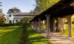
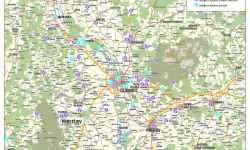
         aktuálně 27.4 °C jasno 03.07. | jasno | 24.5 °C 04.07. | oblačno | 21.2 °C 05.07. | slabý déšť | 20.8 °C | Museum of Historical CarriagesThe largest museum of historic carriages in the Czech Republic comprises 38 carriages from the years 1750-1920. A rarity is the Archbishop's carriage, which starred in the film about Empress Sissi. The rarest exhibit in the museum is the Golden Carriage, made in France in 1750. You will find traveling carriages, mourning carriages, sleighs, harnesses, lanterns and archival documents. During the tour, you will also visit the restoration workshop where you can compare the difference between a repaired and a dilapidated carriage and the art of restoration. Every year in July, the popular international meeting of master carriage makers - JOSEFKOL - takes place in the chateau park. In addition to carriage rides, you can enjoy craft demonstrations, concerts, stunt shows and workshops for children and adults. 0%
| ||||||||||||||||||||||||||||||||||||||||||||||||


The system of interactive links for individual records in selected modules within the project Central Moravia - mainly quiet (2024) was implemented with the support of the state budget of the Czech Republic from the programme of the Ministry for Regional Development.
The optimization of the website and the online campaign within the project Adrenalin after ours (2023) were realized with the contribution of the state budget of the Czech Republic from the programme of the Ministry for Regional Development.
The website was created within the framework of the project Marketing TO Central Moravia 2020 implemented with the contribution of the state budget of the Czech Republic from the programme of the Ministry for Regional Development.
The operation and activities of Střední Morava – Sdružení cestovního ruchu (Central Moravia – Tourism Association) were supported by funds from the Czech Republic's state budget under a program of the Ministry of Regional Development of the Czech Republic.